Geospatial, geomatic, and geographic information systems (GIS) data are having a moment: From precision mapping and surveying, to monitoring troop movements in Ukraine or tracking thousands of submarine cables, the world now depends on geospatial data to a degree most people don’t realize.
- But geospatial and similar companies have a data volume problem: Slow geospatial data processing and movement between systems can profoundly hinder time to value.
- Escalating data volumes are largely driven by the increased availability of satellites, connected devices, and remote sensing technologies.
- Geospatial companies, professionals, and their clients often contend with lengthy data processing times thanks to the vast amount of data and limitations of on-prem infrastructure.
Cloud-based managed file transfer can provide more dynamic and effective ways of orchestrating massive data volumes, and multiple data formats, across stakeholders and geographies. Here’s how.
Table des matières
Reliable, Accelerated Data Transfer—Anywhere
Big data professionals trust MASV to get massive datasets from the field to storage or other stakeholders.
What is Geospatial Data?
Geospatial data includes data about any item, event, or object relative to where it exists on the Earth’s surface. Often used interchangeably with Geographic Information System (GIS) data, geospatial data refers to any data type in this realm while GIS refers only to data that works within GIS software.
Unlike other data types, geospatial data always refers to a physical location (or multiple locations) somewhere in the world. Geospatial data is always location-based but can include other information such as time stamps, which provide greater context and allow for more dynamic analysis.
Some of the most popular use cases for geospatial data include site selection, urban planning, mapping, surveying, network planning, risk assessment, environmental monitoring, and infrastructure development.

Why Is There So Much Geospatial Data?
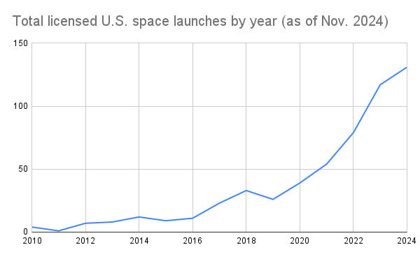
There’s been an explosion in the volume of geospatial data, partly thanks to advancements in AI, mobile scanning, and Earth observation (i.e. satellites). According to the CB Insights Tech Trends 2025 report:
- Cheaper access to space, thanks in part to commercial space companies like SpaceX, has jumpstarted several startups focused on advanced propulsion and satellite technology.
- The cost to reach Earth’s orbit has fallen by 8X since 2008, with SpaceX’s Falcon Heavy able to bring a kg worth of payload into space for nearly 90% less cost ($12,600 vs. $1,500) than the company’s earlier Falcon 1 rocket.
- This proliferation of better, cheaper technology in space has improved communications, monitoring capabilities, and risk management, helping startups expand geospatial use cases for national defense and industrial mapping purposes.
- The number of space launches has increased 5X in the past five years, with 1,935 objects launched in 2023.

Data source: CB Insights Tech Trends Report 2025
This crescendo of activity has led massive amounts of capital to flow into startups focused on satellites and space infrastructure, according to CB Insights.
Geospatial/GIS Data File Formats
There’s a wide array of file formats comprising geospatial and GIS data, with the most popular being pixel-based raster and mathematical equation-based vector files.
Some of the most popular geospatial file formats that also work with GIS software include:
| Data Type | File Format Examples |
| Vector | Esri Shapefile (.SHP, .DBF, .SHX); Geographic JavaScript Object Notation (.GEOJSON); Geography Markup Language (.GML); Google Keyhole Markup Language (.KML, .KMZ); GPS eXchange Format (.GPX); MapInfo TAB (.TAB, .DAT, .ID, .MAP, .IND); Digital Line Graph (.DLG); Geographic Base File-Dual Independent Mask Encoding (GBF/DIME); IDRISI Vector (.VCT, .VDC). |
| Raster | ERDAS Imagine (.IMG); American Standard Code for Information Interchange ASCII Grid (.ASC); GeoTIFF (.TIF, .TIFF, .OVR); IDRISI Raster (.RST, .RDC); Envi RAW Raster (.BIL, .BIP, .BSQ). |
| Geographic Database | Esri File Geodatabase (.GDB); Esri Personal Geodatabase (.MDB); OGC GeoPackage (.GPKG); Mapbox MBTiles (.MBTILES). |
| LIDAR | ASPRS LiDAR Data Exchange Format (.LAS, .LASD, .LAZ); Point Cloud XYZ (.XYZ). |
| CAD | Autodesk Drawing (.DWF, .DWG, .DXF); Bentley Microsystems DGN File Format (.DGN). |
Other geospatial data formats include Elevation, Web, Multitemporal, GIS Software Project, Cartographic, 3D, Interchange, Indoor Mapping, and other miscellaneous file formats.

Geospatial Data: Pain Points
Companies who work with geospatial data must often send large datasets from the field, or from satellite ground stations and receivers—when conducting surveys or mapping topographies with drones or satellites, for example—to other stakeholders or storage.
Most geospatial projects need to link multiple data sources and types together to achieve the most effective analysis. Because geospatial datasets usually consist of thousands of files, that means sending large file packages, often involving multiple file types, of hundreds of gigabytes (GBs) every day—often multiple times per day.
These ever-increasing data volumes have led most organizations in the geospatial space (sorry, couldn’t resist) to move to cloud-based storage such as Amazon S3, which offers faster processing times than many on-prem deployments with far less expensive scale-up costs.
💡 Lire la suite: How to Upload Data to Amazon S3, and From S3 to Glacier
But actually getting all that geospatial data into S3, other storage platforms, GIS platforms, or to other stakeholders to run analysis remains a productivity-killing bottleneck for many companies.
- This very often slows down data processing, data transfer, and data ingestion times—especially when transferring data physically or using out-of-date technology such as the Protocole de transfert de fichiers (FTP).
- It also means that GIS and other companies who work with geospatial data are often forced to choose between ingesting large amounts of data, keeping turnaround times within reason, and keeping infrastructure costs under control.
- Adding to these data pressures is the need for data integration to improve insights and measurement effectiveness: Companies in this space often integrate and link multiple datasets.
While a more effective data analysis technique, these dataset integrations inevitably lead to larger and more unwieldy datasets that are harder to transfer between stakeholders and to storage, leading to slower time to value.
How Cloud-Based File Transfer Alleviates Geospatial Data Transfer Pain
Cloud-based file transfer can help geospatial and similar companies move mountains of data into storage or to other stakeholders faster and more reliably, even in areas with little to no connectivity, compared to other options.
This complements geospatial and similar use cases around LIDAR mapping, remote capture of images and video, and AI processing.
- Easy-to-use, browser-based transfer tools like MASV can send and receive extremely heavy files of up to 15TB (or unlimited sized file packages).
- An accelerated file transfer network optimized for high-speed fiber optic internet—including 10Gpbs pipes—that takes advantage of every bit of speed available without being a network bully.
- File transfer resilience that can recover automatically from internet connection failures without starting over via checkpoint restart.
- Channel bonding tools (available via the MASV Desktop App) that let you combine internet connections (such as a satellite link and 5G hub) allow for fast, reliable transfer even when using hotel WiFi or in other areas with spotty connectivity, such as remote islands.
💡 Lire la suite: Maximize File Transfer Speeds With Channel Bonding
- Simple user interfaces and no complex installations mean these tools don’t require training or tutorials for those in the field, nor a heavy IT lift to get up and running.
- Out-of-the-box enterprise-grade security (in-flight and at-rest encryption) and compliance tools (SOC2, ISO27001, and TPN Gold) mean geospatial teams can share data without worrying about data breaches, which are more common among self-hosted transfer platforms.
- API and developer tools empower developers to integrate cloud-based transfer with geodatabases and other essential applications.
Geomatics professionals can simplify their transfer workflows by using cloud file transfer as a centralized uploader to storage, so admins don’t need to grant direct access to storage to dozens or hundreds of stakeholders.
Automated file transfer tools mean receiving and manually adding files to storage quickly becomes a thing of the past: Organizations can use Dossiers de montres at the satellite downlink to transfer data immediately to constituents or storage for processing and other uses.
Note: MASV supports over 25 storage destinations—including Amazon S3 and various storage classes such as S3 Glacier for cloud archive, along with connected on-prem SAN and NAS storage.
MASV: The Perfect Tool For Geospatial Data Transfer Workflows
MASV is a secure cloud-based file transfer service that already works with several geospatial and similar companies to accelerate and improve geospatial data transfer workflows.
MASV connects to virtually any geospatial data source, allowing it to transfer massive datasets efficiently and eliminate file size restrictions common in traditional file transfer methods like FTP or Aspera. This faciliates effortless movement of content across various cloud and multicloud, on-prem, and hybrid systems.
Customers can also scale their data transfer needs according to project requirements with flexible, cost-effective, and tailored pricing options, from pay-as-you-go to enterprise custom pricing.
S'inscrire à MASV for free today and get 10GB of transfer credits every month to test your geospatial data transfer workflows.
Ingestion sans friction vers n'importe quel stockage en nuage
Connect MASV to your favorite cloud platform, or connected on-prem storage, with no-code integrations and transfer automations.